About Cherry Ridge Airport
| Country |
United States |
| State |
PA |
| Airport Identifier: ICAO |
N30 |
| Airport Identifier: IATA |
N30 |
| Latitude |
41-30-56.1300N |
| Longitude |
075-15-5.6150W |
| Elevation |
1357.0 ft |
| Variation |
13W |
| From City |
3 miles S of HONESDALE, PA |
| Customs Landing Rights |
No |
| Sectional Chart |
NEW YORK |
| Ownership |
Privately Owned , Managed by Cherry Ridge Airport, Inc. |
| Owner |
EARLYNN AVIATION |
| Address |
30 BOMBER LANE HONESDALE, PA 18431
|
| Manager |
Richard Quitoni |
| Address |
30 BOMBER LANE HONESDALE, PA 18431
|
| Office |
570-253-5833 |
| Airport Use |
Privately owned, public use facility |
| Control Tower |
No |
| ARTCC |
NEW YORK CENTER |
| FSS |
WILLIAMSPORT FLIGHT SERVICE STATION |
| Attendance |
0900-1700 |
| Wind Indicator |
Yes (lighted) |
| Segmented Circle |
No |
| Lights |
SS-SR |
| Beacon |
White-Green (Lighted Land Airport) |
| ID |
Dimensions |
Surface |
Weight Bearing Capacity |
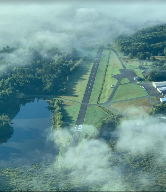
| 18/36 |
2986 ft x 50 ft / 910.1 m x 15.2 m |
Asphalt, Fair Condition |
| Single Wheel |
10.0 |
| Double Wheel |
N/A |
| Double Tandem |
N/A |
| Dual Double Tandem |
N/A |
|
18/36 Details
| Title |
18 |
36 |
| Latitude |
41-31-10.5000N |
41-30-41.7600N |
| Longitude |
075-15-10.0500W |
075-15-1.1800W |
| Elevation |
1346 ft |
1329 ft |
| Traffic Pattern |
left |
left |
| True Bearing |
167 |
347 |
| Magnetic Variation |
13W |
13W |
| Markings |
Basic, Good condition |
Basic, Good condition |
| Crossing Height |
N/A |
N/A |
| Displaced Threshold |
519 ft |
589 ft |
| Declared Distances |
| TORA |
N/A |
| TODA |
N/A |
| ASDA |
N/A |
| LDA |
N/A |
|
| TORA |
N/A |
| TODA |
N/A |
| ASDA |
N/A |
| LDA |
N/A |
|
| VASI |
N/A |
N/A |
| Glide Slope Angle |
0° |
0° |
| RVR Equipment |
N/A |
N/A |
| Approach Lights |
N/A |
N/A |
| Runway End Identifier |
No |
No |
| Obstruction |
69 ft Tree, 1075 ft from runway<br>151 ft left of center line, 12:1 slope to clear |
37 ft Tree, 409 ft from runway<br>57 ft left of center line, 5:1 slope to clear |
| Centerline Lights |
No |
No |
| Touchdown Point |
No |
No |
| Instrument Approaches |
N/A
|
N/A
|
Closest Alternate Airports with Instrument Procedures
| 33PN – LACKAWANNA COUNTY 911 CENTER – 14.2 nm SW from N30 |
| K70N – SPRING HILL – 14.4 nm SW from N30 |
| NY03 – SKYTOP – 24.8 nm NE from N30 |
| NY14 – WYDE – 24.9 nm NE from N30 |
| K9N3 – SEAMANS FIELD – 26.6 nm NW from N30 |
| KMSV – SULLIVAN COUNTY INTERNATIONAL – 26.9 nm NE from N30 |
| KMPO – POCONO MOUNTAINS MUNICIPAL – 27 nm SW from N30 |
| KAVP – WILKES-BARRE/SCRANTON INTERNATIONAL – 27.4 nm SW from N30 |
| WN53 – STROUDSBURG-POCONO – 33.5 nm SE from N30 |
| KFWN – SUSSEX – 39.2 nm SE from N30 |
Communications for CHERRY RIDGE Airport (N30)
| CTAF |
122.80 |
| UNICOM |
122.80 |
| ATIS |
N/A |
| WILKES-BARRE Approach |
124.5
|
| WILKES-BARRE Departure |
124.5
|
| Clearance Delivery |
N/A |
Type of Radar Data for CHERRY RIDGE Airport (N30)
| Primary Approach Call |
RADAR
|
| Primary Departure Call |
RADAR
|
| Radar Type |
N/A
|
Nearby ASOS/AWOS for CHERRY RIDGE Airport (N30)
| WX AWOS-3 at MSV (23.3 nm NE from N30) |
Phone: 845-583-5056 |
| WX ASOS at MPO (23.4 nm SW from N30) |
Phone: 570-839-1584 |
| WX ASOS at AVP (23.8 nm SW from N30) |
1.6Phone: 570-655-0748 |
| WX ASOS at FWN (34.1 nm SE from N30) |
Phone: 973-875-0859 |
| WX ASOS at 12N (38.3 nm SE from N30) |
Phone: 917-786-7221 |
Pilot’s Lounge
Open 24-hours/7-days a week
Computer access with WiFi, comfortable seating with access to restrooms.
Courtesy Car
First come, first serve basis
Buy fuel from our airport
Use the Cherry Ridge Airport Courtesy Car
And fill the tank before the car is returned
Reach out to the airport Manager
Rich Quitoni to schedule your access to the car
Richard Quitoni
Airport Manager
Office: 570-253-5833
To reserve the airport Courtesy Car please reach out to the Airport Manager, Rich Quitonin .
The current price of fuel is $5.399